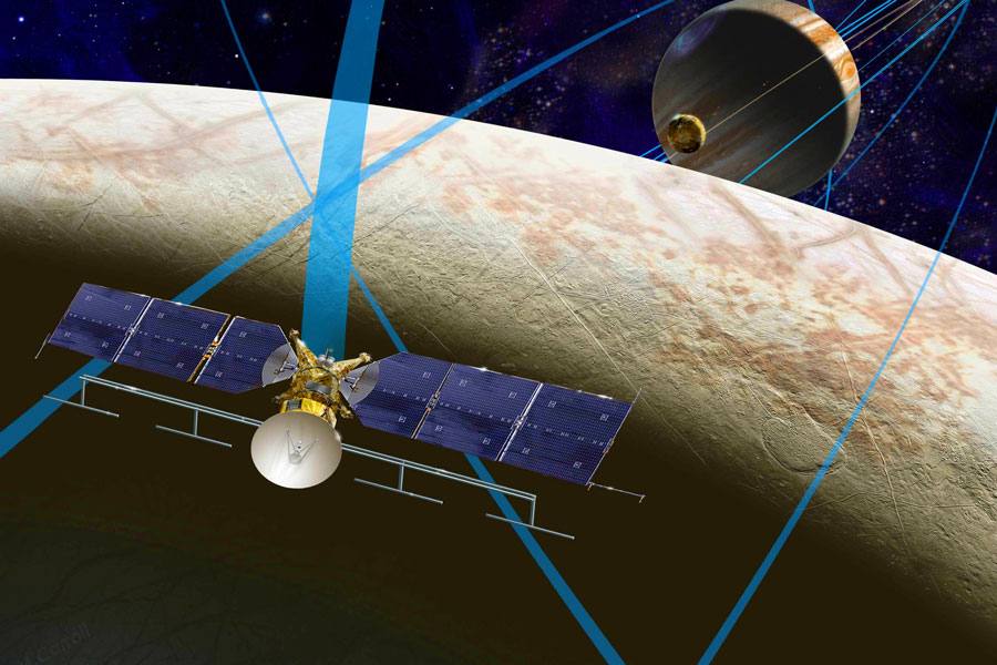
Imaging Spectroscopy
Above: JPL's Mapping Imaging Spectrometer for Europa (MISE) will probe the composition of Europa. MISE will be identifying and mapping the distributions of organics, salts, acid hydrates, water ice phases, and other materials to determine the habitability of Europa's ocean. The principal investigator for MISE at JPL is Dr. Diana Blaney.

Imaging Spectroscopy

Spectroscopy is a key analytical method used to investigate material composition and related processes through study of the interaction of light with matter. Determining composition remotely, without physical contact, is one of the most valuable capabilities of spectroscopy.

In the late 1970's, detector, optical and computer technology advanced sufficiently to enable a class of instrumentation that could measure a spectrum for every point in an image. Development of the Airborne Imaging Spectrometer (AIS) began in 1979 at the NASA Jet Propulsion Laboratory. Based on the success of AIS, a more capable instrument, the Airborne Visible-Infrared Imaging Spectrometer (AVIRIS) was developed for NASA Earth science. AVIRIS measures the visible to short wavelength infrared (VSWIR) spectral range from 380 to 2510 nm and first flew in 1986.

AVIRIS and other subsequent imaging spectrometers have been used to pursue a wide range of scientific investigations including ecosystem canopy chemistry, composition, and function; surface geologic and soil composition; coastal ocean and inland waters properties and benthic composition, including corals, snow, ice albedo, grain size, impurities, and melting; fire fuel, combustion, severity, and recovery; atmospheric water vapor, carbon dioxide, methane, cloud phase, aerosols; and anthropogenic infrastructure properties. JPL is a world-class leader in the development of imaging spectrometers that both look out into space and down onto Earth.

JPL Microdevices Laboratory (MDL) has been leading development of various microfabricated parts for hyperspectral imagers for years, creating critical parts such as the hemispherical blazed grating and open air slits. The air slits are arguably the world’s highest quality open-air slits. These slits help diffract out the light into their spectral components. In 2010 a JPL imaging spectrometer (AVIRIS) was flown over the Gulf of Mexico oil spill to gather data. To increase chemical sensitivity, both spectral resolution and the signal-to-noise ratio must be optimized. To facilitate this, a new class of materials has been developed for insertion into the JPL slits – black silicon. Black silicon is normal silicon that has been etched in such a way that creates an ultra-rough surface that absorbs almost all light.

AVIRIS extensively mapped the Gulf region affected by the 2010 Deepwater Horizon oil spill disaster for the National Ocean and Atmospheric Administration
NASA's AVIRIS extensively mapped the Gulf region affected by the 2010 Deepwater Horizon oil spill disaster for the National Ocean and Atmospheric Administration.
+ Larger image
maps showing where there are are live trees to provide seed and regrow the forest, which dead trees could endanger workers and what habitats have been created for fire-dependent wildlife species
After the California Megafires, JPL AVIRIS-Classic data was combined with U.S. Forest Service data and to produce maps showing where there are are live trees to provide seed and regrow the forest, which dead trees could endanger workers and what habitats have been created for fire-dependent wildlife species.
+ Larger image
ER-2 aircraft can go to 70,000 feet (21,300 meters), almost twice as high as a commercial airliner, and was used by NASA scientists with a JPL imaging spectrometer to study environmental impacts caused by the Southern California wildfires
NASA's ER-2 aircraft can go to 70,000 feet (21,300 meters), almost twice as high as a commercial airliner, and was used by NASA scientists with a JPL imaging spectrometer to study environmental impacts caused by the Southern California wildfires.
+ Larger image


Imaging Spectroscopy

Products & Processes

Image from MDL Core Competency Project: Dust Sources

Dust Sources

Does mineral dust blown into the atmosphere cause it to warm or cool? This is the fundamental question that researchers hope a new space-based instrument will help them answer. Since much of the Earth’s desert...

LEARN MORE>>
Image from MDL Core Competency Project: AVIRIS-NG

AVIRIS-NG

The National Academies’ report of the Decadal Survey for Earth Science and Applications from Space (released January 2018 and available at: http://www.nas.edu/esas2017) identified Surface Biology and Geology (SBG)...

LEARN MORE>>
Image from MDL Core Competency Project: SWIS

SWIS

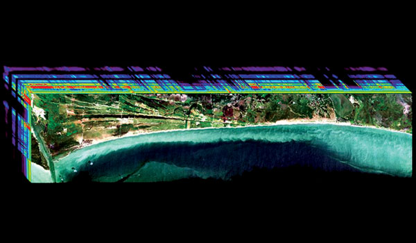
In spaceflight, getting two sets of important scientific data for the price of one is always a benefit. The snow and water imaging spectrometer (SWIS) combines the ability to image spectra from the dark surface...

LEARN MORE>>
Image from MDL Core Competency Project: Moon Mineralogy

Moon Mineralogy

JPL’s Moon Mineralogy Mapper (M3) imaging spectrometer successfully completed its mission aboard the Indian Space Research Organization's Chandrayaan-1 spacecraft. The M3 science team reported the discovery...

LEARN MORE>>
Image from MDL Core Competency Project: NextGen Vis/IR

NextGen Vis/IR

After the success of JPL’s AVIRIS-NG hyperspectral imaging system, even further improvements were conceived at JPL with input from a range of stakeholders. The Next Generation Imaging Spectrometer (NGIS) resulted...

LEARN MORE>>
Image from MDL Core Competency Project: UV Spectroscopy

UV Spectroscopy

What's the best way to measure the chemical composition, densities, and temperatures of the spaces between stars, the temperature and composition of hot young stars themselves, or the compositions of planetary atmospheres? Ultraviolet...

LEARN MORE>>
Back to top